
Festival of Legends 2026: Year of Luck
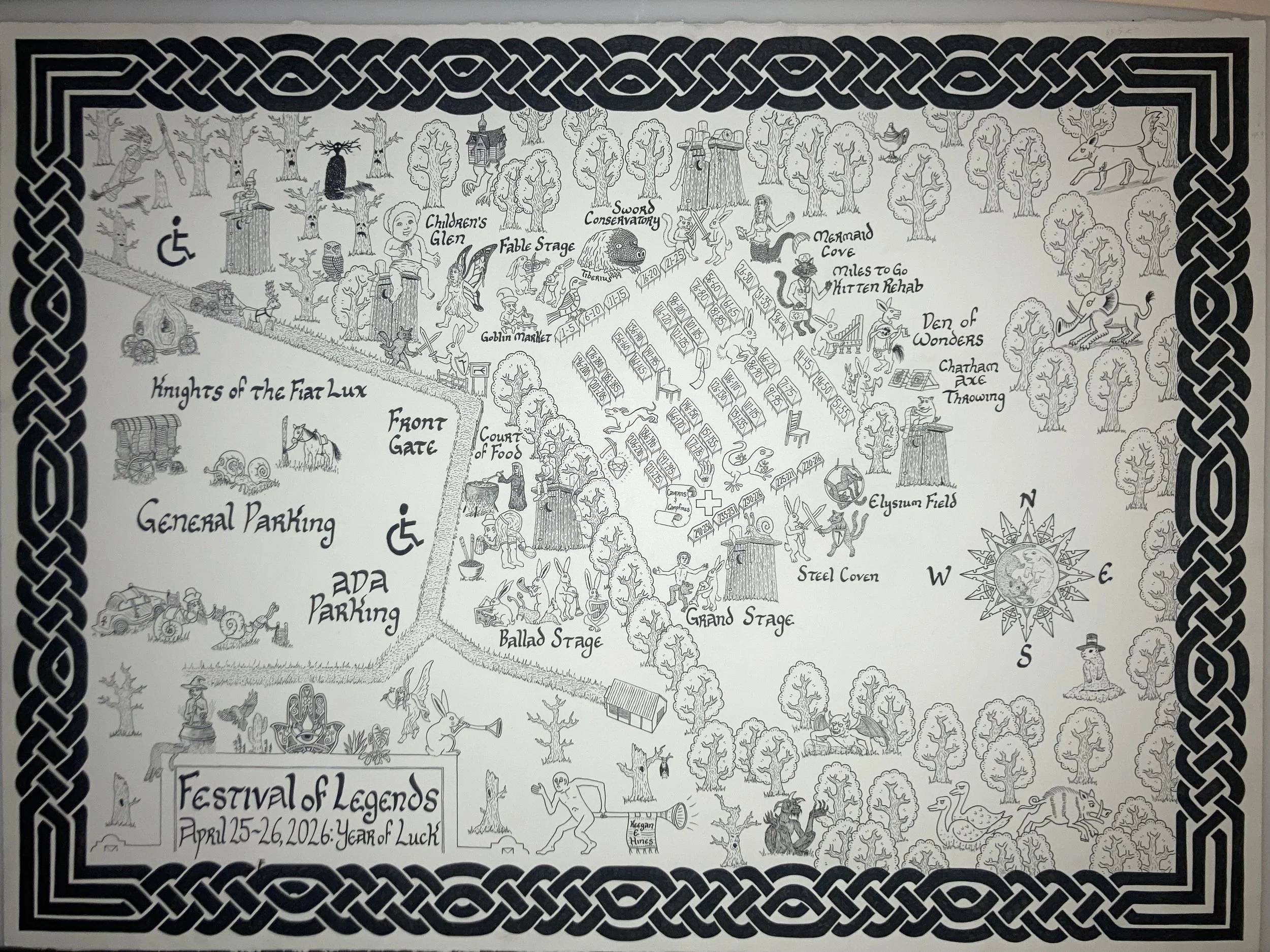
I’ve recently completed the site map for this year’s Festival of Legends (April 25-26th at Sugg Farm, NC). ‘Tis replete with creatures symbolizing either good or ill fortune. We’re looking forward to showcasing our maps (including some gilded editions of Beregond’s Map of Middle Earth) at the market - come find us in our medieval-style canvas tent. Come one, come all!
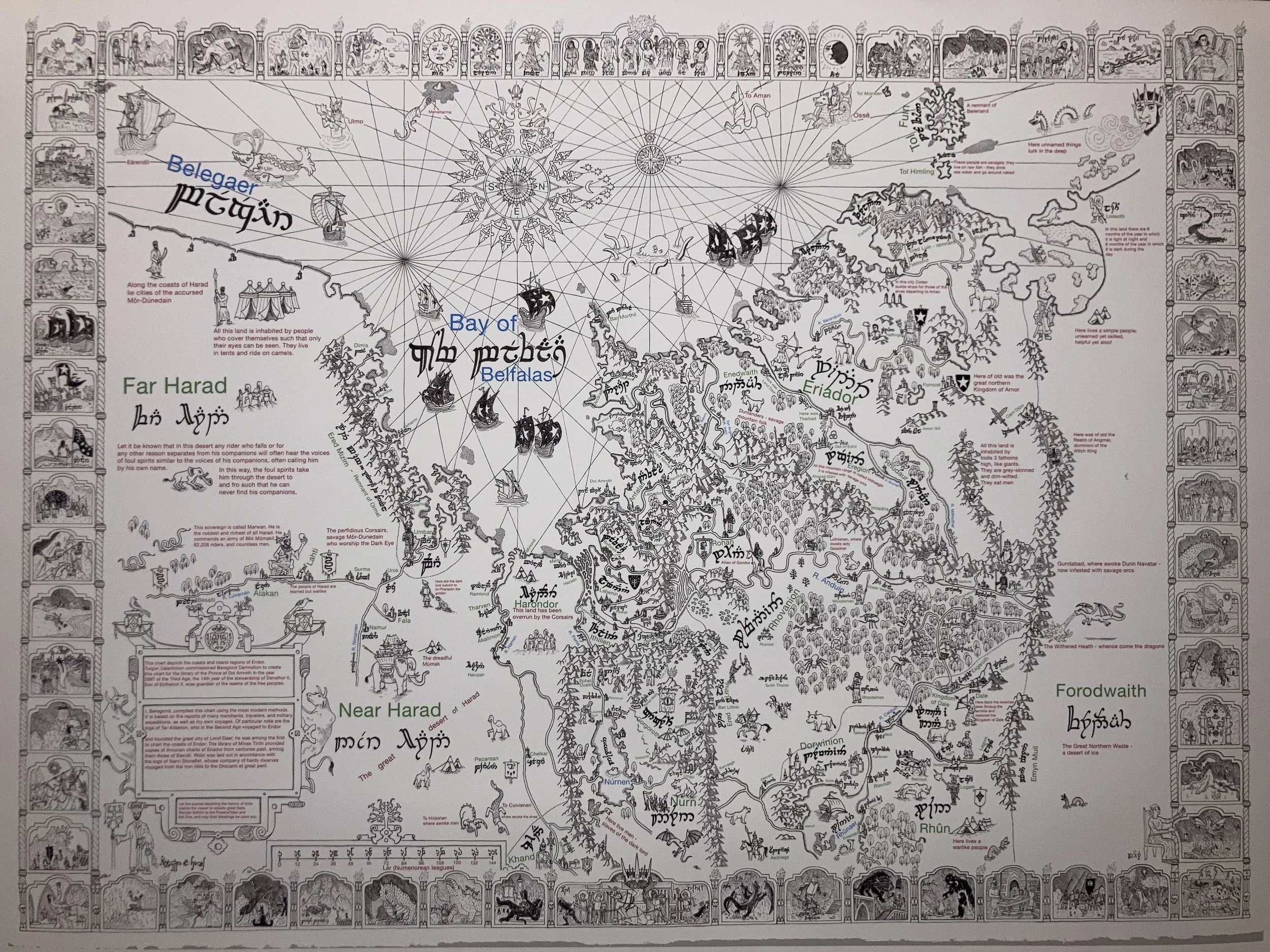
Beregond’s Map Transliteration
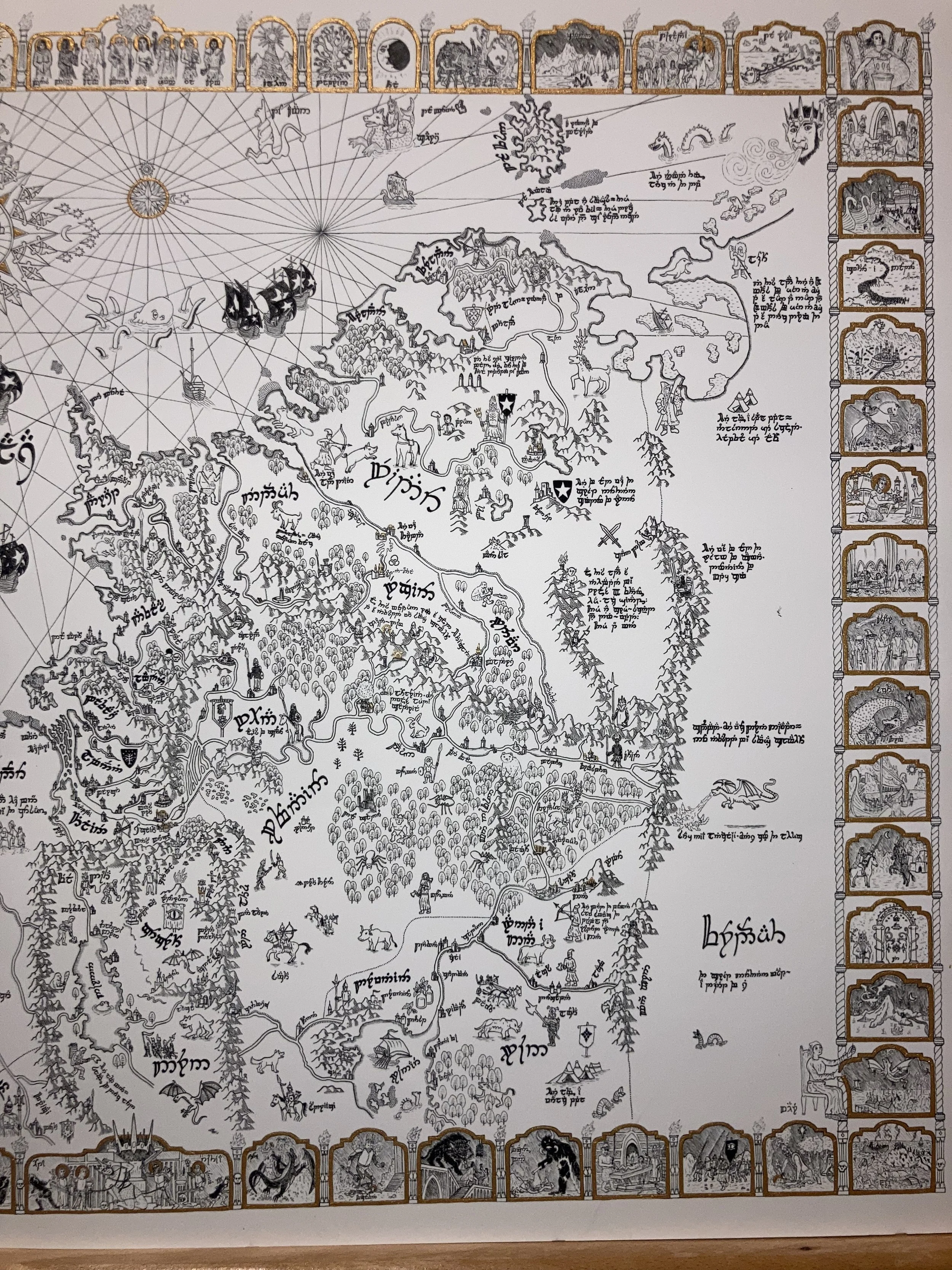
Full picture of the transliterated version of Beregond’s Map of Middle Earth
I finished working on this, my most recent map, not too long ago. I drew the original design without the transliteration on 22x30 inch Arnhem cotton paper using archival ink. We now have a number of related products available (all written in the original Tengwar, without any Latin letters):
Standard prints of the map are 20x30 inches, perfect for display and maintaining a high level of detail.
Small prints at 18x24 inches - for those looking to take up less wall space, while not being so small as to lose the details
Gilded prints at 20x30 inches - I have so far gilded 5 prints by hand using dip pens and Windsor and Newton gold calligraphy ink. It has a nice metallic sheen and imparts a more medieval feel to the map. I’ll likely gild some more when I can find the time; it takes 2-3 hours for each map.
High-quality prints on watercolor paper — I recommend these for any who wish to watercolor the map themselves. I have 3 such prints at the moment and will be able to procure more if there’s enough interest.
Beregond’s Map - my original design and the design I use for all prints - written fully in Tengwar characters.
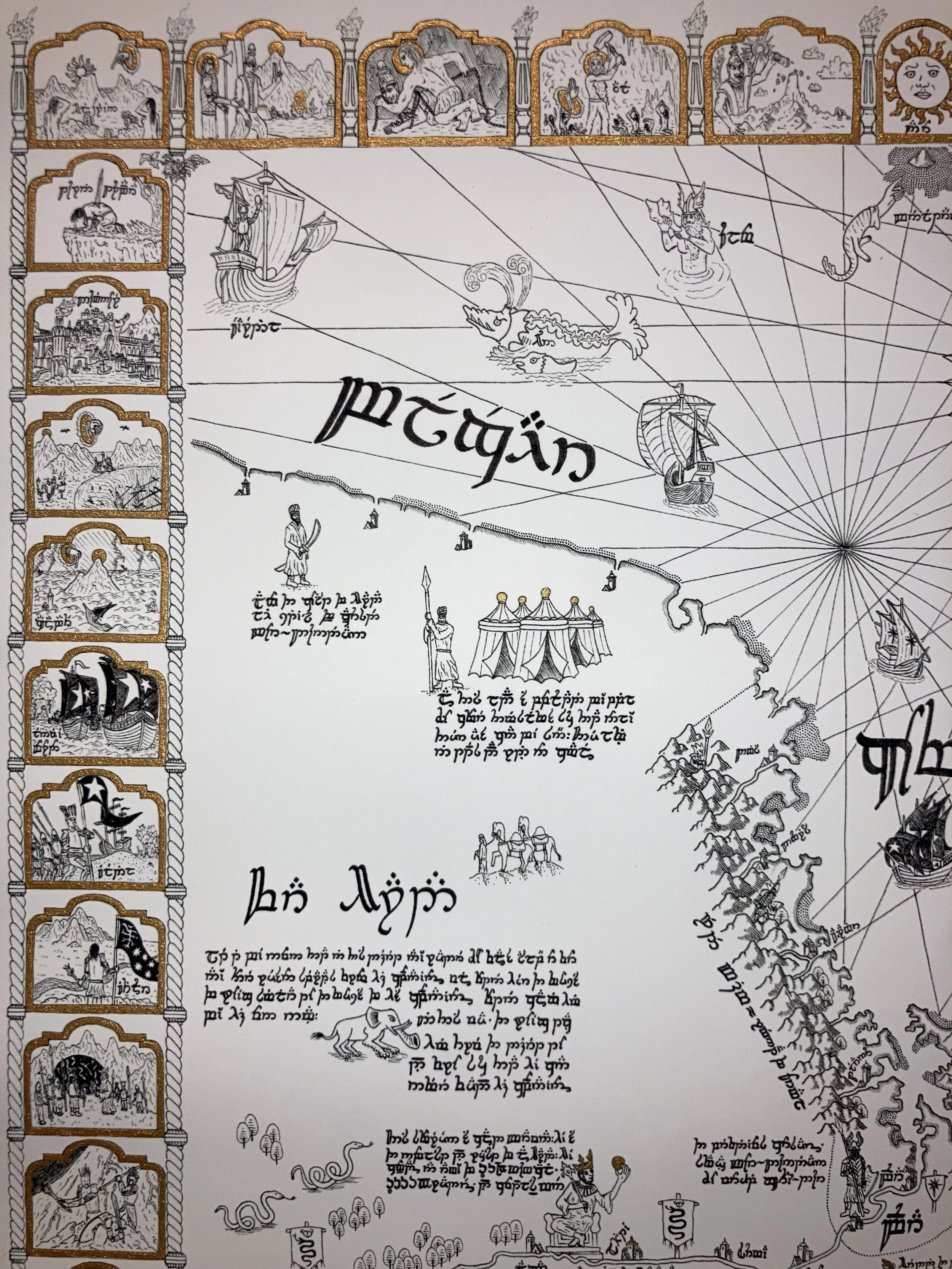
In designing this map to appear like an in-world artifact, I drew much inspiration from medieval and early modern European cartography, so it was a no-brainer to look to the inscriptions of the Catalan Atlas of 1375 when deciding what to write. The Catalan Atlas is remarkable for its accurate depiction of the Mediterranean and Black Sea regions, as well as its relatively secular and factual descriptions of the peoples living there. Of course, the map greatly distorts not only the geography of the more eastern regions it depicts, but also describes them in outlandish terms, leading to some fun inscriptions such as “The men of this land are twelve fathoms high, like giants. They are grey-skinned and dim-witted. They eat men.” and “These people are savages. They live on raw fish; they drink sea water and go around naked.” I referenced many of these inscriptions, but made some alterations to make them better fit Middle Earth. I also came up with many other inscriptions drawing on my research and some suggestions by folks online, including the reference to Tar-Aldarion in the cartouche in the lower lefthand portion of the map.
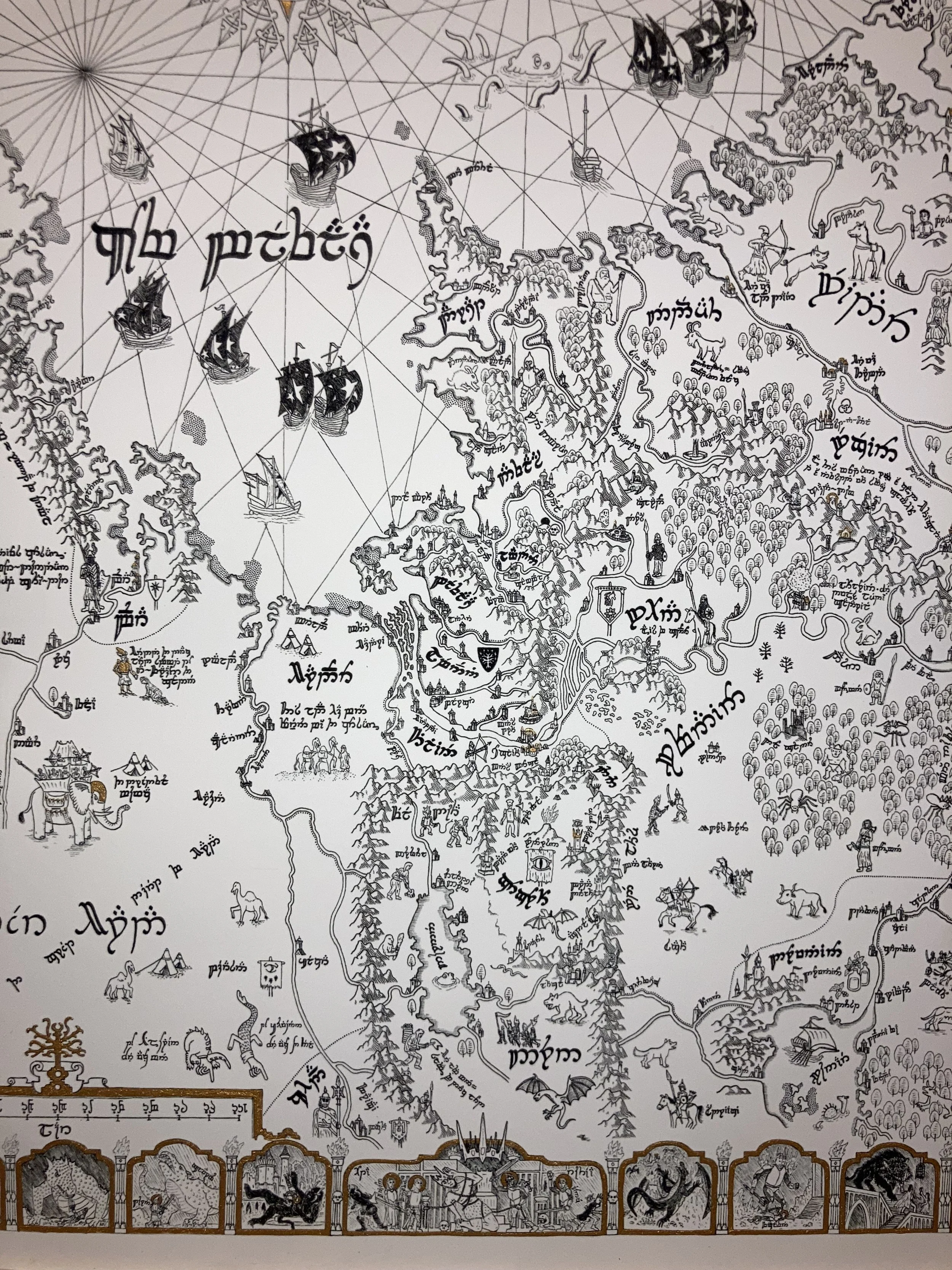
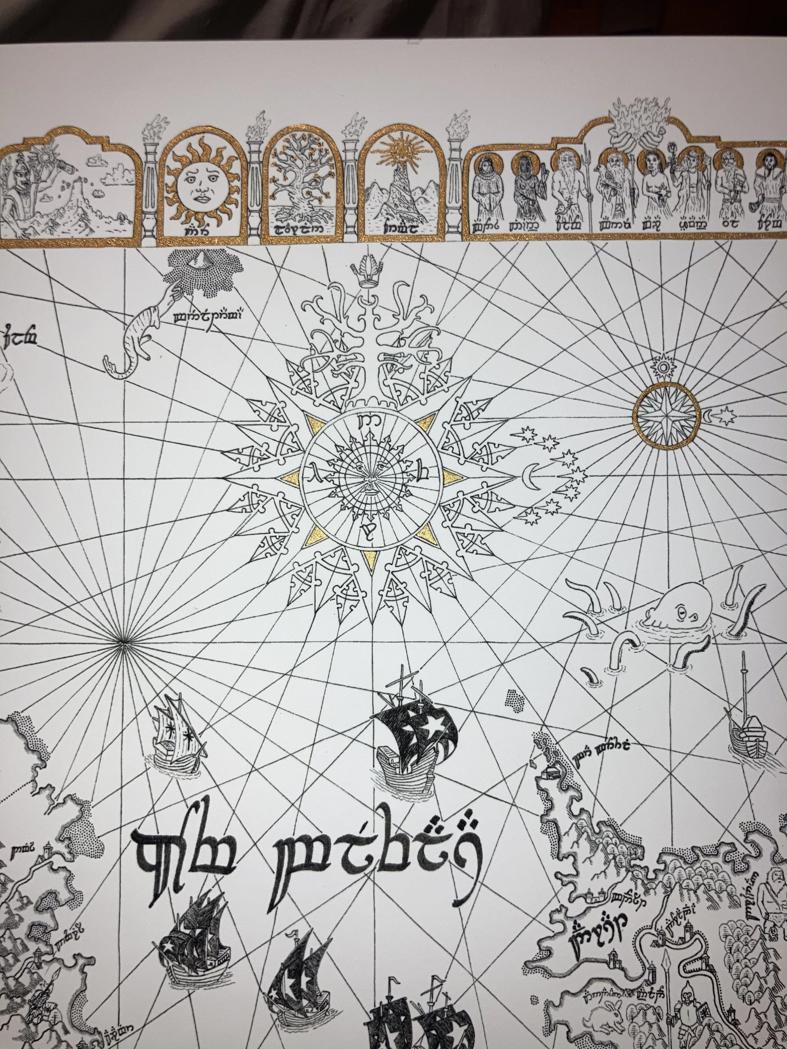
From top right — Ormal (the southern Lamp of the Valar); Laurelin (the Golden tree that replaced Ormal and preceded the sun); the sun; Morgoth destroys the Lamps of the Valar; Aulë prepares to destroy the dwarves he created in repentance for seeking to create life, which is Eru Ilúvatar’s place alone, but Eru stays his hand; first chaining of Melkor at the hands of Tulkas after his defeat in the War for the Sake of the Elves and the destruction of his first great fortress of Utumno; Melkor unchained in Valinor after an age of captivity; men awaken in Hildórien; Túrin Turambar ends his life; Númenor; the hand of Eru ends Ar-Pharazôn the Golden’s invasion of the Undying Lands and drowns Númenor while the faithful escape to Middle Earth.
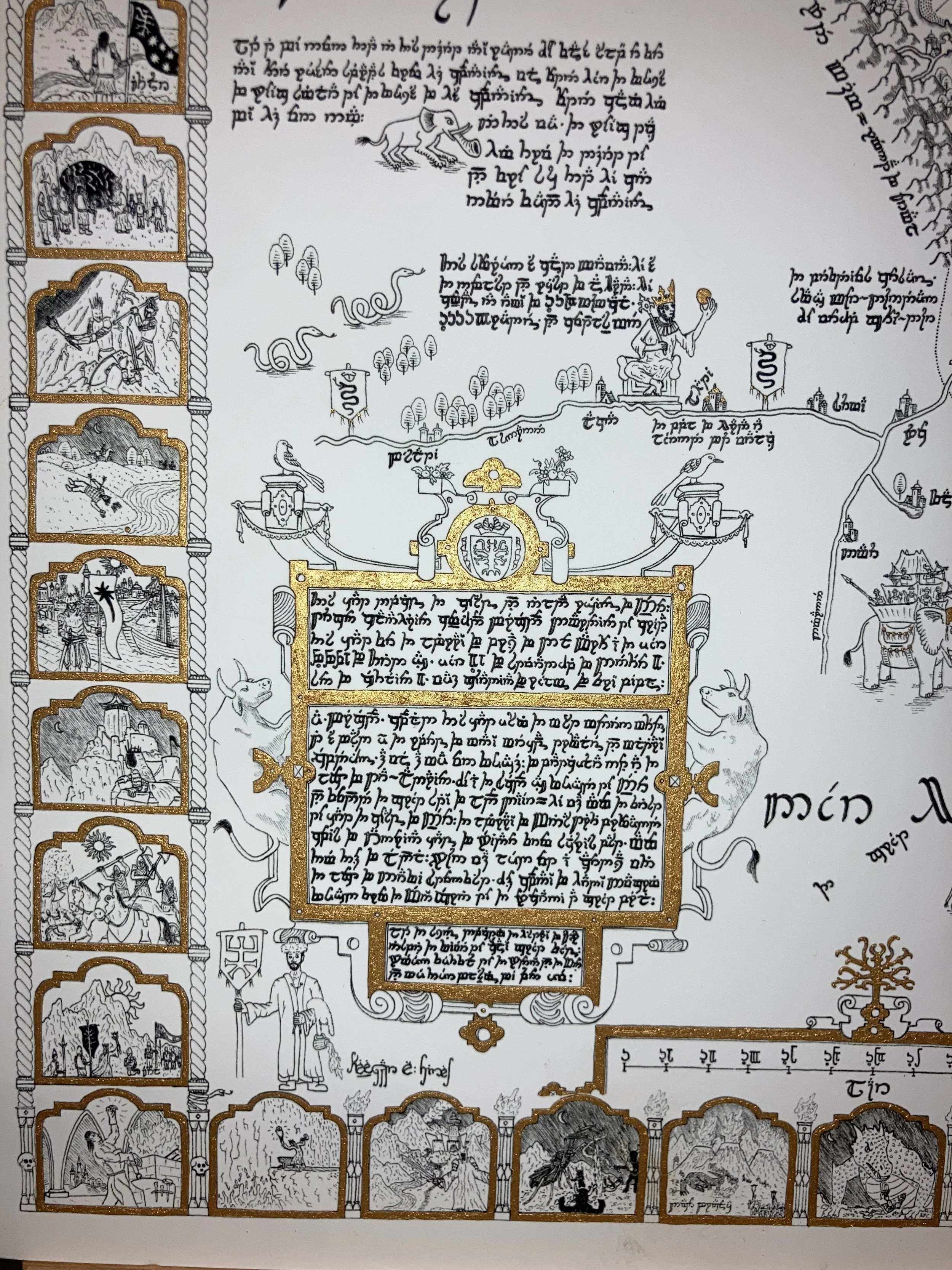
The Meneltarma, the sacred mountain at the heart of Númenor, is depicted on this map, surrounded by rocky shoals or sandbars. It has not been seen since the doom of Númenor, but is said to still poke above the waves. In reality, it should be much farther to the south and west, but given that it hasn’t been seen in three thousand years, its exact placement is less important than depicting it for its religious significance.
One fact I found particularly interesting is that the Gondorian and Elvish number systems use base 12. As such, when laying out the scale I had it go from 0 to 144 lár (Gondorian leagues) in increments of 12. The inscription next to the Haradrim sovereign Marwan (modeled on the Catalan Atlas’s depiction of Mansa Musa) describes him as commanding an army of 864 Mûmakil, 62,208 riders, and countless men. Likely an overestimate by a large margin made by far-off Gondorian scholars and military officials, these numbers seem oddly specific in base 10 — but in base 12 they are represented as nice round numbers, as we might expect estimates to be. What we represent in base 10 as 864 would be written as 600 in base 12, and what we represent as 62,208 in base 10 would be rendered as a nice round 30,000 in base 12.
The inscription in the cartouche references Tar-Aldarion - the sixth king of Númenor, first of the Dúnedain to venture back to Middle Earth since their forefathers fled the sinking of Beleriand at the end of the First Age.
The cartouche also references Elendil’s maps of Eriador. Elendil, father of Isildur, led the Faithful as they fled from the Doom of Númenor, and it was he who founded the great northern kingdom of Arnor near the end of the Second Age. Arnor fell into ruin by the middle of the Third Age, while its southern counterpart in Gondor prospered. Gondorians are avid seafarers, but as of the late Third Age they have only loose connections now with inland Eriador, so would likely be reliant on old charts of the region for their maps.
The great port of Umbar is controlled by the Black Númenoreans (Môr Dúnedain), so called because, unlike the Faithful, they turned from the Valar and Eru Ilúvatar and took to worshipping Sauron and Morgoth in pursuit of achieving immortality. Umbar and Gondor have long been enemies. Gondor was once able to subdue and conquer Umbar, but it has since regained its independence and expanded its maritime power as Gondor’s influence waned over the late Third Age. The Corsairs of Umbar have even established a foothold in Harondor, or South Gondor. They are described in this map as perfidious, or oath-breaking.
Ar-Pharazôn the Golden is depicted twice in this map - once in Near Harad where he captured Sauron before bringing him to Númenor, and once in the iconographic border, being sucked into the earth alongside his army and fleet by an act of Eru Ilúvatar as a result of his blasphemous invasion of the Undying Lands, which led to the downfall and drowning of Númenor by Eru’s hand.
At top - the Valar, with the hands of Eru carrying the Flame Imperishable above them. To either side - the lights of the world. First came the Lamps of the Valar, which Morgoth cast down before the awakening of the elves. Then the Valar gathered the light up again and concentrated it in two trees which lit the world from the Undying Lands - it was under the light of the trees that elves awoke and migrated from Middle Earth to Aman. At this time the Valar broke Morgoth’s first fortress of Utumno and chained him for an entire age. After being released from his captivity by the Valar, Morgoth collaborated with the giant spider-like entity Ungoliant to destroy the trees immediately before fleeing back to the now-darkened Middle Earth. The Valar gathered the light of the trees and used it to create the sun and the moon in defiance of Morgoth. While Morgoth was defeated and cast into the Void at the end of the First Age, he will return at the end of days and destroy the sun and the moon before initiating the Dagor Dagorath, the Battle of All Battles.
In the ocean are depicted the ships of the Faithful fleeing the destruction of Númenor and landing in Middle Earth to establish the kingdoms of Gondor and Arnor.
In this part of the map two maniculae point towards the far-eastern birthplaces of men and elves.
Wainriders, scourge of Gondor, are depicted transiting the eastern steppe of Rhovanion from Rhûn.
From bottom left: Turin slays Glaurung, Father of Dragons; Ecthelion slays Gothmog, lord of the Balrogs, at the Fall of Gondolin; the second chaining of Morgoth in the depths of Angband after his defeat in the War of Wrath, after which he was cast into the Void; Eärendil in his flying ship smites Ancalagon the Black upon the Thangorodrim outside Angband; Fingolfin injures Morgoth’s foot as he is crushed to death in his duel with the dark lord.
Here unnamed things lurk in the deep - a reference to Morgoth’s fortress Angband, which was drowned along with Beleriand at the end of the First Age, some five thousand years before the Fellowship’s quest. Who knows which of Morgoth’s foul creatures survived the destruction of his fortresses of Utumno and Angband, lurking in caverns far beneath the world’s surface.
Also depicted is Mount Gundabad, where the dwarves first awoke. It has been hotly contested between dwarves and orcs for millennia.
King Arvedui, last king of Arthedain, a successor kingdom to Arnor, is drowned in his ship in the Ice Bay of Forochel after departing from his exile among the Lossoth. His kingdom was undermined by the Witch King’s Realm of Angmar.
The map depicts great ancient cities of the Dúnedain, now ruined — Lond Daer, Tharbad, Annuminas, and Fornost.
The Tower Hills which once housed the palantiri are also shown.
In the northeastern section of the map are depicted were-worms and the horned beast of Rhûn.
From bottom right: Morgoth ravaging sun Maia Arien; orcs on the march; Morgoth and Sauron torture an elf in Utumno; Gothmog, Fingon’s Bane — Gothmog slays the high king of the Noldor; Beren and Luthien in Angband, stealing a silmaril from Morgoth and confronting Sauron in his werewolf form.
Thanks for reading! We have another post coming soon, in which we’ll be showing off the gilded version of the map. I enjoyed gilding a few of the prints and I’m happy with how they turned out; they have a somewhat more medieval feel and really make the map stand out.
“Simple land, simple thing. We have so many places… World is big; a place enough. … Yee, c’mon.” — Speak
Gilding Beregond’s Map
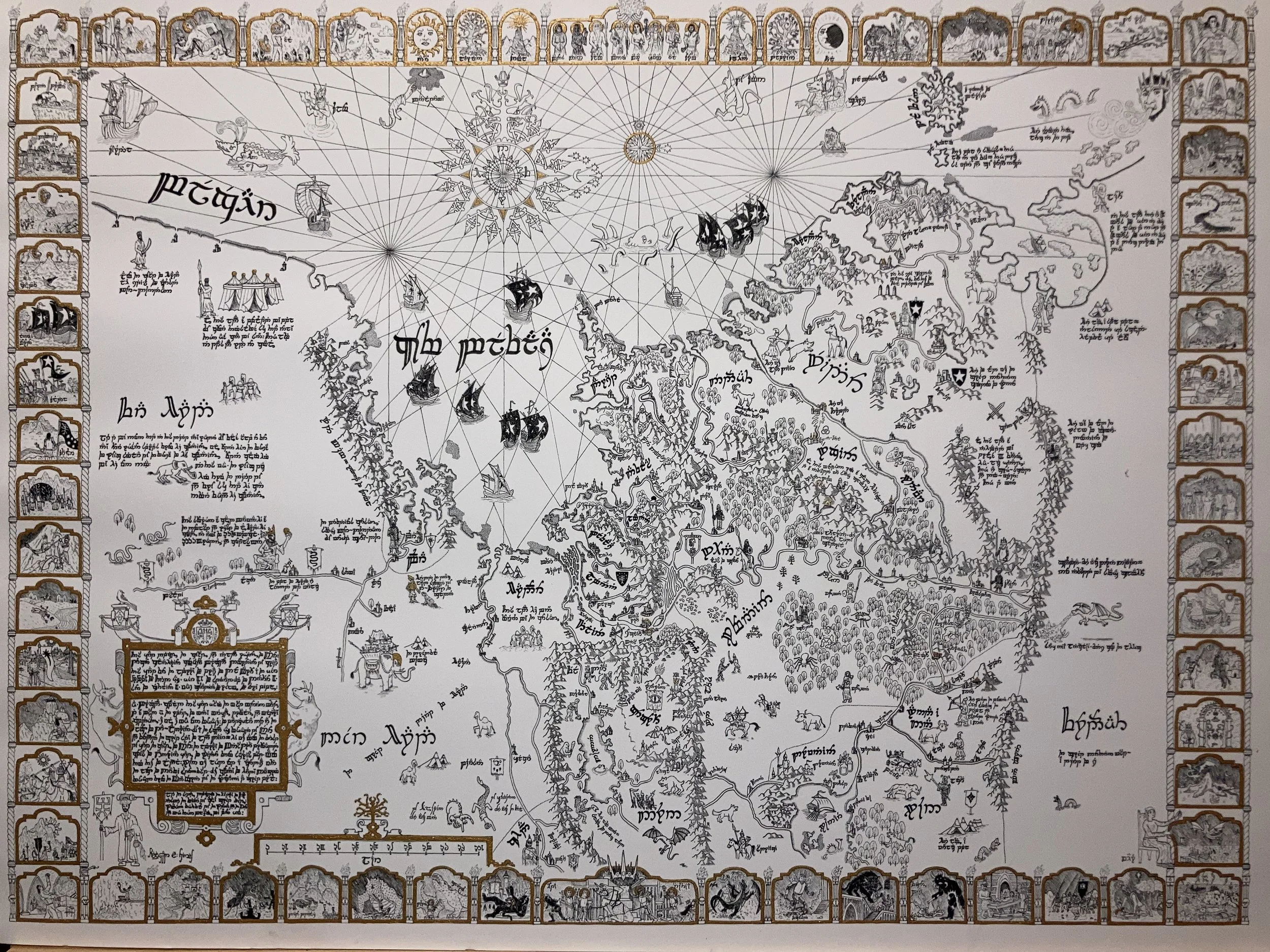
As previously discussed, I got around to gilding a few prints of Beregond’s Map. I used dip pens and Windsor & Newton gold calligraphy ink to do so. It took me about 2-3 hours to apply the ink to each print. I’m happy with how they turned out - I think the ink has a nice metallic sheen and really makes the maps pop as well as imparting a more medieval feel to the work, highlighting the most important or sacred elements of the map.
I’ve gilded five prints so far, but may make more if there is enough interest. :)

Mansa Musa depicted on the Catalan Atlas of 1375

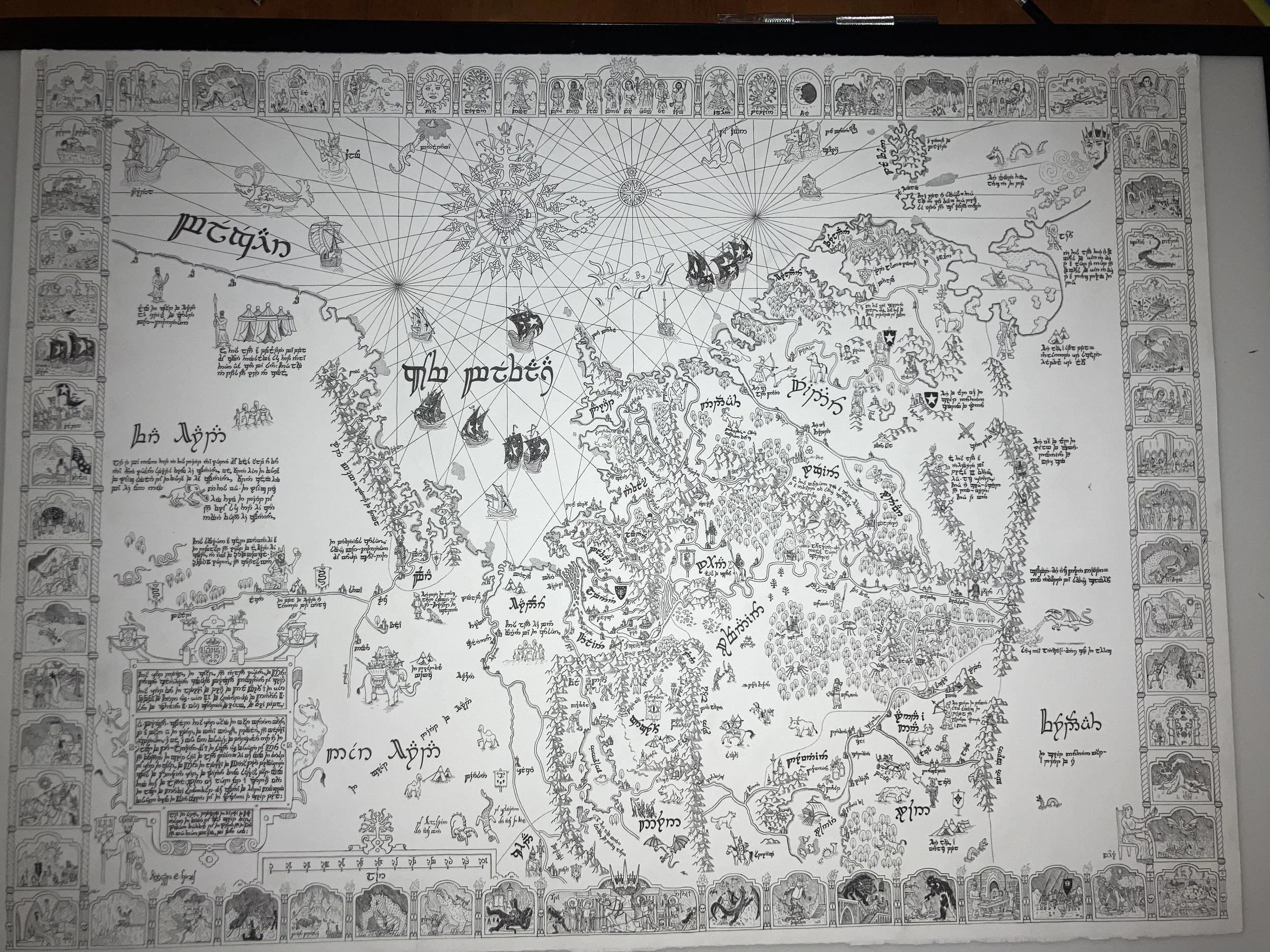
Beregond’s Map of Middle Earth
It’s finally here!

Beregond’s Map: 22x30 inches, Arnhem 1618 art paper, Ticonderoga pencils, Sigma Micron pens with archival ink
Greetings and salutations! Apologies for the delay, but the wait is finally over. I finished work on my map of Middle Earth at 5am on a Thursday, just in time to get it scanned and order prints for a lovely festival we attended in Pennsylvania called Forrest of the Fae. Definitely check them out here if you get the chance; we have every expectation of joining them next year.
I am especially excited about this project, my latest map. I drew it from the perspective of a Gondorian cartographer in the late Third Age, after Sauron's return to Mordor but before his defeat in the War of the Ring. The map is oriented to the West, towards Numenor-beneath-the-waves and the Undying Lands, and the geography is somewhat distorted, especially the further one gets from Gondor, to reflect the limits of premodern mapmaking technology.
The map features various inscriptions in Tengwar as well as an iconographic border depicting scenes from the Silmarillion. I've recently acquired a light-box and will be able to trace a second version of the map to make a watercolor edition. The black and white original has already been sold (though my first draft using the Pentel Energel pens has not), but the watercolor original will also be up for sale once I finish it sometime next year, and I’ll get the scan so that we can have colored prints as well.
I’ll be sharing a translation of the map in the coming weeks, for any who are interested.

Southern half of Beregond’s map
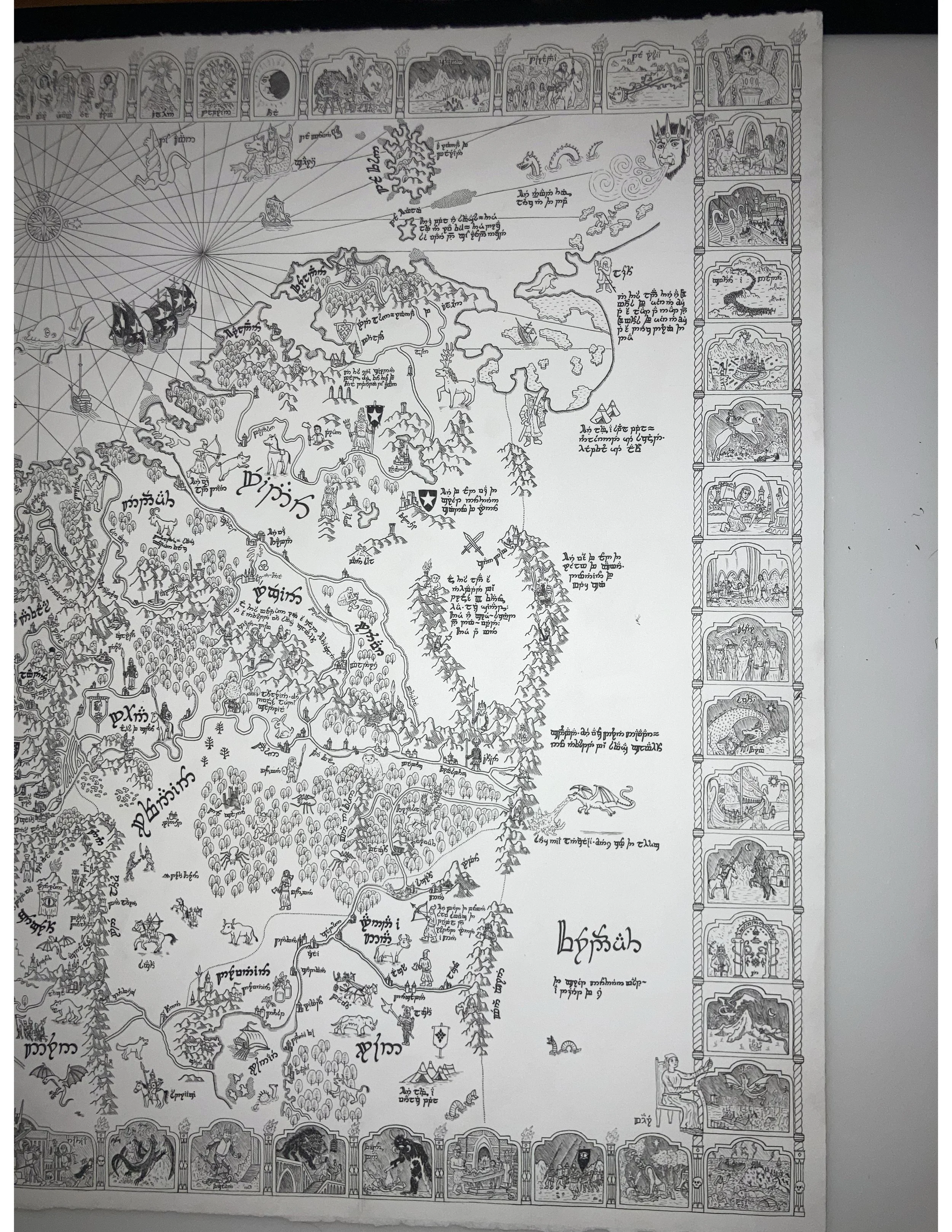
Northern portion of Beregond’s Map

Scale for Middle Earth, units in Lár
In referencing various historical maps, especially Linschoten’s work, I knew I wanted to include a scale on Beregond’s map. I had to determine the unit of distance used by Gondorians - Lár, roughly a league, or three miles, about as far as an army marches without taking a breather. I made certain that the scale would be fairly accurate with regard to distances in and around Gondor itself by referencing the scale in Tolkien’s book maps and converting miles to Lár. I had to determine how many Lár to include on the scale - would it be 0-100, counting in increments of ten, or some other number? As it turns out, the Elves and some of the learned men use base 12 (and Beregond’s map is supposed to be in Sindarin, which could be used among the learned of Gondor similar to the use of Latin as a language of religious and academic import in medieval and early modern Europe). That’s why the scale goes from 0 to 144 in 12 increments of 12 Lár each.

“This sovereign is called Marwan. He is the noblest and richest of all Harad. He commands an army of 864 Mûmakil, 60,000 riders, and countless men.”
There is one other significant place where I make use of numbers - in the inscription near powerful Haradrim King Marwan, inspired by the Catalan Atlas’s depiction of Mansa Musa and its description of a North African Sultan. “This sovereign is called Marwan. He is the noblest and richest of all Harad. He commands an army of 800 Mûmakil, 60,000 riders, and countless men.” Until I was working on my updated version of the map using waterproof archival ink and calligraphy pens, it didn’t occur to me that 800 and 60,000 are not nice round numbers in base 12, so they would come across as oddly specific estimates, especially for guessing the size of a foreign army, which is likely wildly overestimated to begin with. On the physical original that I scanned to make prints, I corrected 800 (represented in base 12, hereafter indicated by bold text, as 568) to 864, a nice round number in base 12: 6(12^2), represented as 600. But dingus that I am, I just figured that since 60,000 is already divisible by 12 that I’d leave it as is - but 60,000 is only evenly divisible by 12 once, so it would be a sort of oddly specific estimate, written as 2A880 where A=10. I just got around to rounding this number out to 62,208 - which is 3(12^4), or 30,000.

“This sovereign is called Marwan. He is the noblest and richest of all Harad. He commands an army of 864 Mûmakil, 62,208 riders, and countless men.”
The first batch of 21 ;) maps that we ordered all contain the numbers 864 and 60,000. All subsequent maps contain and shall forevermore contain the numbers 864 and 62,208.
Just a wee fix. By the way, this is part of the reason Biblical and and other ancient texts often provide what seem to us to be oddly or impossibly specific estimates - many premodern societies used base 12, base 6, or another base system for counting.
Well gang, that’s all for this time. In case you’re local and would like to come chat with us about maps, we will be at the Arts On Market in Chapel Hill on November 23rd. Check out their website here for more information. And thanks again for tuning in! It’s been a blast working on and finishing up this project, but as always, there are many more in the planning stages that we can talk about next time. Until then!

Welcome to Mapsterpiece!
Welcome to Mapsterpiece, a blog about maps! In addition to finally getting out our first newsletter, I've also finally come around to writing a blog, which I will try to update in tandem with the newsletter. If you’re joining in from there, welcome! And if not, but you’d like to see Drunk Kitten in your inbox, feel free to sign up at the bottom of the Home page.
Let’s get in to our exciting new developments, as well as some progress photos to show you what I'm working on currently.
A blog about maps and other fun stuff
Greetings! In addition to finally getting out our first newsletter, I've also finally come around to writing a blog, which I will try to update in tandem with the newsletter. If you’re joining in from there, welcome! And if not, but you’d like to see Drunk Kitten in your inbox, feel free to sign up at the bottom of the Home page.
Let’s get in to our exciting new developments, as well as some progress photos to show you what I'm working on currently.
Progress photo of a Gondorian cartographer’s map of Middle Earth
New Partnerships
First, I'm happy to announce that Drunk Kitten Cartography is now partnering with Flights and Fables fantasy and destination travel company. They specialize in designing and booking your dream getaway, doing all the tricky planning stuff so that you can just enjoy the experience. I’m really excited to be partnering with a such an enthusiastic group of people. I’ve always enjoyed traveling, and I think their idea of creating a magical getaway for people just adds that extra layer of fun to a trip that can make it so memorable. Check out their website and contact them through the link above, and receive one our our map prints as a commemoration of your fantastic trip!
Additionally, the Moon Dog Meadery in Durham and Sidequest Game Lounge and Bar in Raleigh have been gracious enough to put my maps on display (and for sale) in their spaces. Please visit them, and enjoy games and a nice brew while getting lost in the maps, or in your bottle. Or both, no judgement.


Current Projects
Middle Earth: 22x30 inches, Arnhem 1618 art paper, Ticonderoga pencils, Pentel Energel 0.3mm gel pens
I am especially excited about this map of Middle Earth. I am drawing it from the perspective of a Gondorian cartographer in the late Third Age, after Sauron's return to Mordor but before his defeat in the War of the Ring. The map is oriented to the West, towards Numenor-beneath-the-waves and the Undying Lands, and the geography is somewhat distorted, especially the further one gets from Gondor, to reflect the limits of premodern mapmaking technology.
The map features various inscriptions in Tengwar as well as an iconographic border depicting scenes from the Silmarillion. I expect to have the black-and-white original done sometime in early summer, at which time prints will be available (sign up for our newsletter if you’re interested in hearing about the release).
I've recently acquired a light-box and will be able to trace a second version of the map onto watercolor paper using non-water-soluble ink, so there will eventually be a watercolor original as well, and colored prints to boot.
This map's style is different in many ways from what I'm used to. I'm drawing a lot of stylistic inspiration from Jan van Linschoten and Olaus Magnus, who worked as cartographers in the 16th century. Many of the inscriptions are at least partially inspired by the 1375 Catalan Atlas, which was remarkably accurate for its time (if not in its inscriptions, then at least in its depiction of the Mediterranean and Western Europe!)
Map of Great Britain (a.k.a. Perfidious Albion) and Ireland
Britain and Ireland: 15x22 inches, Arnhem 1618 art paper, Ticonderoga pencils, Pentel Energel 0.3mm gel pens
This is another map I'm excited about, though I haven't had much time to devote to it lately. Alas, drawing maps by hand is slow and meticulous work, and there are only so many hours in the day (and night) that I can spend drawing. I received a lot of suggestions as to what to include on this map and will try to fit in as much detail as I can without overcrowding. Hoping to finish this map right after releasing the Gondorian Cartographer’s Map of Middle Earth. (I’ll be needing to come up with a shorter title for that one…)
And last, but not least…
North Carolina: size TBD
"How do you not already have a map of North Carolina?!" one might ask, to which I would answer: because I am a dingus and a goof. I suppose it’s also because home is less alluring than far-off lands, though I will admit it has some interesting and beautiful geography of its own. I got started on a full-size map of the state over a year ago, but given time constraints, I'll probably start over with a small or medium-sized version first. This will be my third state map after California and Texas (not counting Hawai'i and Pennsylvania, which are in need of a redesign). New York and Florida are also planned, after which I might leave it there unless I get a commission for another state. I know some have gone about designing beautiful maps of each and every state, but I have no such ambition.
Until Next Time…
That’s all for now! We hope to see you out in the world at some of our upcoming events. And if you can’t make it to those, no worries. We’ll always have the wonderful world of the Internet. And this blog. Definitely easier to find us here.
Best,
Keegan and Hannah

Our Drunk Kittens